Physical Address
304 North Cardinal St.
Dorchester Center, MA 02124
Physical Address
304 North Cardinal St.
Dorchester Center, MA 02124

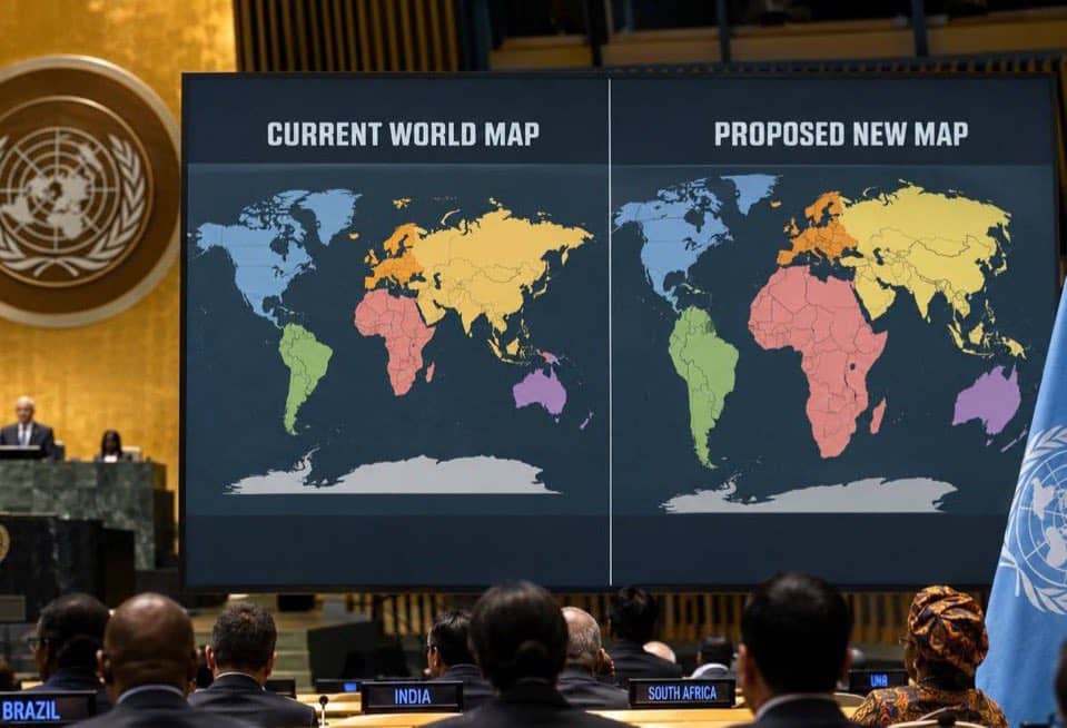
The United Nations General Assembly has backed a new approach to world mapping that gives a more accurate picture of the relative size of Africa and other continents, following an initiative led by Togo and supported by the African Union.
The resolution, adopted on September 4, 2026, encourages the use of the Equal Earth projection, which represents the relative surface areas of continents more accurately than the widely used Mercator projection. The vote was overwhelmingly in favour, with 164 countries supporting the resolution, six abstaining and only the United States voting against.
For centuries, the Mercator projection has been one of the most familiar ways of viewing the world. Created by Flemish cartographer Gerardus Mercator in 1569, it was designed primarily for maritime navigation. However, its method of projecting the spherical Earth onto a flat surface makes countries and regions farther from the Equator appear much larger than they actually are.
Africa is one of the clearest examples. On a conventional Mercator map, Africa can appear surprisingly close in size to Greenland, even though Africa is about 14 times larger. The continent covers roughly 30.3 million square kilometres, enough to accommodate the United States, China, India and much of Europe within its landmass.
Togo spearheaded the push for the change on behalf of African states, building on an African Union campaign calling for a fairer representation of the continent. Togo’s Foreign Minister, Robert Dussey, argued that maps influence education and how people understand the world, making accurate representation important beyond geography classrooms.
Importantly, the UN resolution does not ban the Mercator projection. Instead, it encourages governments, schools, international organisations and technology companies to consider Equal Earth and other equal-area projections where accurately showing the size of land masses is important. The Mercator projection can also remain useful for navigation.
Togo has already indicated plans to update its school geography materials, making the country one of the first to put the resolution into practical use.
For Africa, the development has become more than a debate about lines, shapes and measurements on paper. It is being seen as an opportunity to correct a long-standing visual misconception and ensure that the continent is represented closer to its actual geographical scale.